Maps offer hope to save threatened rainforest in Malaysian Borneo’s Sarawak
In Malaysian Borneo, systematic logging has wiped out huge tracts of rainforest. Now, Indigenous groups are turning to new tools to map and protect what remains.

 By Izzy Sasada
Published On 8 Aug 20258 Aug 2025
Long Moh, Sarawak — William Tinggang throws a handful of fish food into a glass-clear river.
A few seconds pass before movement under the water’s surface begins, and soon a large shoal splashes to the surface, fighting for the food.
Recommended Stories
list of 4 itemsend of list
He waits for the underwater crowd to disperse before hurling the next handful into the river. The splashing resumes.
“These fish aren’t for us to eat,” explains Tinggang, who has emerged as a community leader in opposing the logging industry in Long Moh, a village in the Ulu Baram region of Malaysia’s Sarawak state.
“We want the populations here to replenish,” he tells Al Jazeera.
As part of a system known as Tagang – an Iban language word that translates as “restricted” – residents of Long Moh have agreed there will be no hunting, fishing or cutting of trees in this area.
Just a few hours’ flight from Malaysia’s capital Kuala Lumpur, Sarawak is one of two Malaysian states on the island of Borneo that contain some of the oldest rainforests on the planet.
It is an internationally recognised biodiversity hotspot, and within its Ulu Baram region lies the Nawan Nature Discovery Centre, a community-initiated forest reserve spanning more than 6,000 hectares (23 square miles).
The forest in Nawan is dense and thriving; bats skim the surface of the Baram River, palm-sized butterflies drift between trees, and occasionally, monkeys can be heard from the canopy.
The river remains crystal clear, a testament to the absence of nearby activities.

The community’s preservation effort stands in contrast to much of the surrounding landscape in Sarawak, where vast tracts of forest have been systematically cut down for timber extraction and palm oil plantations.
Advertisement
Conservation groups estimate that Sarawak may have lost 90 percent of its primary forest cover in the past 50 years.
Limiting hunting is one of the numerous ways communities in the region are working together to protect what remains of Sarawak’s biodiversity heritage.
For the community of Long Moh, whose residents are Kenyah Indigenous people, the forests within their native customary lands have spiritual significance.
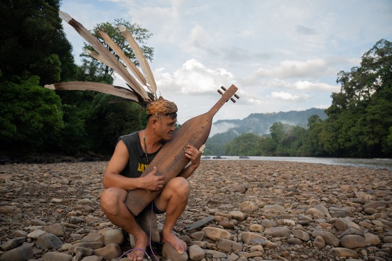
“Nawan is like a spiritual home,” says Robert Lenjau, a resident of Long Moh, who is a keen player of the sape, a traditional lute instrument which is popular across the state and is steeped in Indigenous mythology.
“We believe there are ancestors there,” says Lenjau.
While most Kenyah people have converted to Christianity following decades of missionary influence in the region, many still retain elements of their traditional beliefs.
The community’s leading activist, Tinggang, believes the forest to have spiritual importance.
“We hear sounds of machetes clashing, and sounds of people in pain when we sleep by the river’s mouth,” he explains.
“Our parents once told us that there was a burial ground there.”

Sarawak’s dwindling forest cover
Sarawak’s logging industry boomed in the 1980s, and the following decades saw large concessions granted to companies.
Timber exports remain big business. In 2023, exports were estimated to be worth $560m, with top importers of Sarawak’s wood including France, the Netherlands, Japan and the United States, according to Human Rights Watch.
In recent years, the timber industry has turned to meeting the rapidly growing demand for wood pellets, which are burned to generate energy.
While logging reaped billions in profits, it often came at the expense of Indigenous communities, who lacked formal legal recognition of their ancestral lands, despite their historical connection to the forest and their deep ecological knowledge of the region.
“In Sarawak, there are very limited options for communities to actually claim native customary land rights,” says Jessica Merriman from The Borneo Project, an organisation that campaigns for environmental protection and human rights across Malaysian Borneo.
“Even communities who do decide to try the legal route, which takes years, lawyers, and costs money, they risk losing access to the rest of their customary territories,” Merriman says, explaining that making a legal claim to one tract of land may mean losing much more.
Advertisement
“Because you’ve agreed – essentially – that the rest [of the land] doesn’t belong to you,” she says.
Even successful community claims may only grant rights to a very small fraction of what Indigenous communities actually consider to be their native customary land in Sarawak, according to The Borneo Project.
This also means that logging companies might legally obtain permits to cut the forest in areas which had been previously disputed.
While timber companies have brought economic opportunities for some, providing job opportunities to villagers as drivers or labourers, many Kenyah community members in the Ulu Baram region have negative associations with the industry.

“We don’t agree with logging, because it is very damaging to the forests, water and ecosystems in our area,” says David Bilong, a member of Long Semiyang village, which is about a half-hour boat ride from Long Moh village.
Both Long Moh and Long Semiyang have dwindling populations, with about 200 and 100 full-time residents, respectively.
Extensive logging roads in the region have increased accessibility for the villages, resulting in younger community members migrating to nearby towns for work and sending remittances back home to support relatives.
Those who remain in the village, or “kampung”, live in traditional longhouses which are made up of rows of private family apartments connected by shared verandas. Here, community activities like rattan weaving, meetings and karaoke-singing take place.
Bilong has played an active role in community activism over the years. For him, deforestation activities have contributed to the undermining of generational knowledge, as physical landmarks have been removed from their lived environment.
“It’s difficult for us to go to the jungle now,” he explains.
“We don’t know any more which hill is the one we go to for hunting,” he says.
“We don’t even know where the hill went.”

Tackling encroachment through community-based conservation
For decades, Indigenous communities across Ulu Baram have shown their resistance to logging activities by making physical blockades.
This typically entails community members camping for weeks, or even months, along logging roads to physically obstruct unwanted outsiders from entering native customary territories.
The primary legal framework regulating forest use is the Sarawak Forest Ordinance (1958), which grants the state government sweeping control over forest areas, including the issuance of timber licences.
Now, local communities are increasingly turning to strategic tools to assert their rights.
One of these tools is the creation of community maps.
“We are moving from oral tradition to physical documentation,” says Indigenous human rights activist Celine Lim.
Advertisement
Lim is the managing director of Save Rivers, one of the local organisations supporting Ulu Baram’s Indigenous communities to map their lands.
“Because of outside threats, this transition needs to take place,” Lim tells Al Jazeera.

Unlike official government maps, these maps reflect the community’s cultural landmarks.
They include markers for things like burial grounds, sacred sites and trees which contain poison for hunting with blow darts, reflecting how Indigenous people actually relate to and manage their land sustainably.
“For Indigenous people, the way that they connect to land is definitely a lot deeper than many of our conventional ways,” says Lim.
“They see the mountains, the rivers, the land, the forest and in the past, these were entities,” she says.
“The way you’d respect a person is the way that they would respect these entities.”
By physically documenting how their land is managed, Indigenous communities can use maps to assert their presence and protect their native customary territory.
“This community map is really important for us,” says Bilong, who played a role in the creation of Long Semiyang’s community map.
“When we make a map, we know what our area is and what is in our area,” he says.
“It is important that we create boundaries”.
‘Solid evidence of a community’s territory’
The tradition of creating community maps in Sarawak first emerged in the 1990s, when the Switzerland-based group Bruno Manser-Fonds – named after a Swiss environmental activist who disappeared in Sarawak in 2000 – began supporting the Penan community with mapping activities.
The Penan are a previously nomadic indigenous group in Sarawak who have now mostly settled as farmers.
Through mapping, they have documented at least 5,000 river names and 1,000 topographic features linked to their traditions, and their community maps have been used numerous times as critical documentation to prevent logging.
Other groups, such as the Kenyah, are following suit with the creation of their own community maps.
“The reason why the trend of mapping has continued is because in other parts of Baram and Sarawak, they’ve proven to be successful,” says the Borneo Project’s Merriman, “at least in getting the attention of logging companies and the government.”

Now, local organisations are encouraging communities to further solidify their assertion to their native customary territories by joining a global platform hosted by the United Nations Environment Programme that recognises Indigenous and community conserved areas, known as the ICCA.
Communities participating in the ICCA are listed on a globally accessible online database, and this international visibility offers a place for them to publicise threats and land grabs.
In Sarawak, the international visibility afforded through ICCA registration could offer an alternative avenue of protection for communities.
Merriman says that another important aspect of applying for ICCA recognition is the process itself of registering.
“The ICCA process is fundamentally an organising tool and a self-strengthening tool,” she says.
“It’s not just about being on the database. It’s about going through the process of a community banding together to protect its own land, to come up with a shared vision of responding to threats and what they want to do to try to make alternative income.”
Advertisement
Safeguarding Indigenous communities in Sarawak also has an international significance, activists say.
As the impacts of climate change intensify in Malaysia and globally, the potential role of Sarawak’s rainforests in climate change mitigation is increasingly being recognised.
“There’s plenty of talk at the state level about protecting forests,” says Jettie Word, executive director of The Borneo Project.
“Officials often say the right things in terms of recognising their importance in combatting climate change. Though ongoing logging indicates a gap between rhetoric and reality,” Word says.
“While mapping alone can’t protect a forest from a billion-dollar timber project, when it’s combined with community organising and campaigning, it’s often quite powerful and we’ve seen it successfully keep the companies away,” she says.
“The maps provide solid evidence of a community’s territory that is difficult to refute.”