Salt, rising
Marco Uccellatori, a young agronomist who owns a farm in Taglio di Po that has been producing rice since 1700, is similarly concerned.
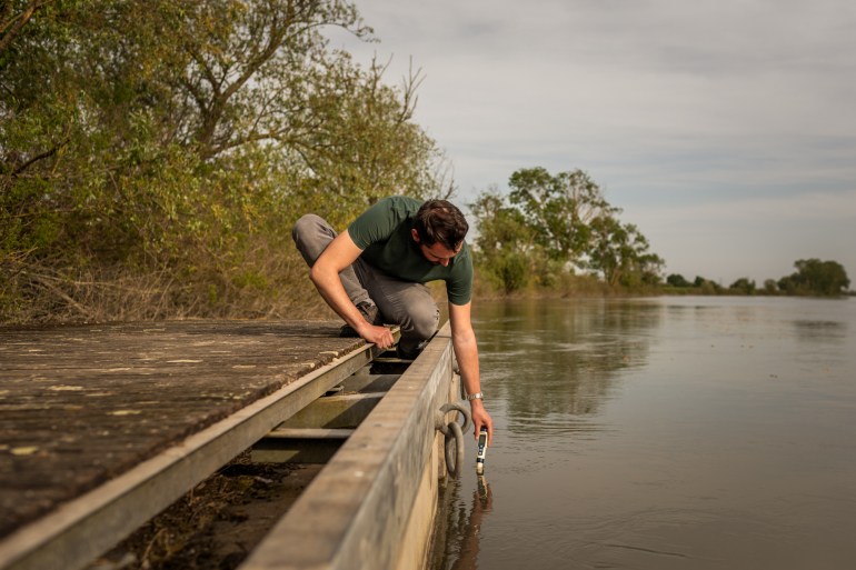
To irrigate his rice fields, he takes freshwater directly from the Po della Pila. “Rice is vital for us. During the summer season, we measure the salinity level of the river water so as not to damage the soil and not to lose the harvest,” he says as he leans out from a small wooden pier to measure the salinity level of the river through a conductivity metre.
Marco Uccellatori, a 29-year-old farmer, measures the level of electrical conductivity of the waters of the Po della Donzella that irrigates his farm in Taglio di Po, Rovigo, Veneto. Through conductivity analysis, it is possible to evaluate the quantity of salt present in the water and determine their use for agriculture [Luigi Avantaggiato/Al Jazeera]
To protect agricultural and industrial areas in Volta Vaccari, in the municipality of Porto Tolle, the Consorzio Bonifica Delta del Po has installed a dam capable of collecting freshwater in a dead branch of the river – a curved lake formed where the main stream of the river has cut across the narrow end of the oxbow and no longer flows around the loop of the bend.
“It is an automated barrier that is activated when the sea current hits it and guarantees one million cubic metres of freshwater for local farms during the most critical periods,” says Laurenti.
The Volta Vaccari barrier in Porto Tolle, Rovigo, Veneto. As the saltwater rises, the barrier closes automatically to ensure the availability of freshwater, equal to 1 million cubic metres, to be allocated to agricultural activities in the area during the critical months [Luigi Avantaggiato/Al Jazeera]
Salt intrusion has reached particularly worrying levels in this region in recent years but the phenomenon has been known since the 1990s, when the Consorzio di Bonifica Delta del Po began installing barriers to limit the spread of salt into the various tributaries.
These are complex installations made up of poles driven into the riverbed perpendicular to the current to which unidirectional mobile fins are anchored. They remain open to accommodate the flow of water towards the sea and close, automatically forming a barrier, when the water from the sea advances towards the river.
The barriers have worked well in the past, but today they run into an insurmountable obstacle: they were calibrated with the minimum flow values of the Po at the time – 450 cubic metres per second – in mind.
Today, lower rainfall means the flow of the river has slowed to around 113 cubic metres per second. This has caused the barriers to be much less efficient – and less able to counteract the incoming flow of seawater, Laurenti explains.